A growing number of technologies are taking to the skies to remotely detect leaking methane. Meanwhile, analysis frameworks are debuting down on Earth to make sense of the data. As these tools expand, so do their differences.
While the technology advances, state and federal regulatory frameworks largely remain the same. This means landfill operators or outside groups may rely on different standards for how to remotely measure emissions or talk about their findings. That could complicate the communication needed to reduce landfill methane through corporate goals or federal programs.
On July 5th, the U.S. EPA announced it is collecting information about "new technologies" that could be incorporated into updated emissions guidelines and standards of performance for MSW landfills. The EPA could eventually regulate how the technologies are deployed, a policy shift that some groups say needs to happen.
“This is about moving from the needle-in-a-haystack to a much more accurate and effective approach of monitoring,” said Katherine Blauvelt, the circular economy director at Industrious Labs, a nonprofit focused on cutting emissions from industrial sectors. “This is not bleeding edge at all.”
While EPA data shows the waste sector’s greenhouse gas emissions have declined in recent years, municipal landfills still release the third-largest amount of human-generated methane in the U.S. Today, about 600 of those locations are required by the Clean Air Act to have a technician walk the surface once a quarter with a handheld methane detection tool.
According to Industrious Labs, these standard protocols might be missing crucial information. In a recent examination of EPA inspection reports, the group found that 21 of 22 examined locations had methane exceedances above 500 parts per million — the federal regulatory limit. It also found that site and federal records about emissions contradicted one another at 10 of these locations.
One way to solve this issue, Industrious Labs suggested, is to adopt more comprehensive and up-to-date methane technology.
Currently, EPA regulations don’t speak to the role that remote detection could play in monitoring and regulating this gas. However, policies for oil and natural gas systems — the second-largest source of methane emissions —do recognize these technologies. Revamped guidelines, effective May 7, allow the EPA to inform owners and operators about “super-emitter” data collected by agency-approved satellites and flyover gear. In some cases, owners will have to fix the source of the greenhouse gases.
Whether the technology is in orbit (like a satellite) or passes closer to the ground (like on a drone or plane), the systems aboard are spectrometers. These devices record light as it bounces off Earth’s atmosphere. More specifically, the spectrometer detects the exact wavelength that methane reflects. When flying past, the device takes a picture of how the methane-specific wavelength is behaving in one spot. An analytics system turns the photo into an estimate of how much methane a given location is emitting.
If the EPA set standards for how remote methane sensing will work in the oil and gas industry, said Blauvelt, then it can do the same for the waste sector. That’s why Industrious Labs is advocating for the federal agency to revise parts of the Clean Air Act to include super emitter interventions for MSW landfills that are similar to what was enacted for oil and gas.
Some remote sensors that could gain EPA approval and accomplish the same tasks for landfills have been operating for years. The commercial enterprise GHGSat, for example, has 12 satellites imaging emissions for fossil fuel and waste industry customers. Other possible remote sensors are just getting started.
Taking to the skies
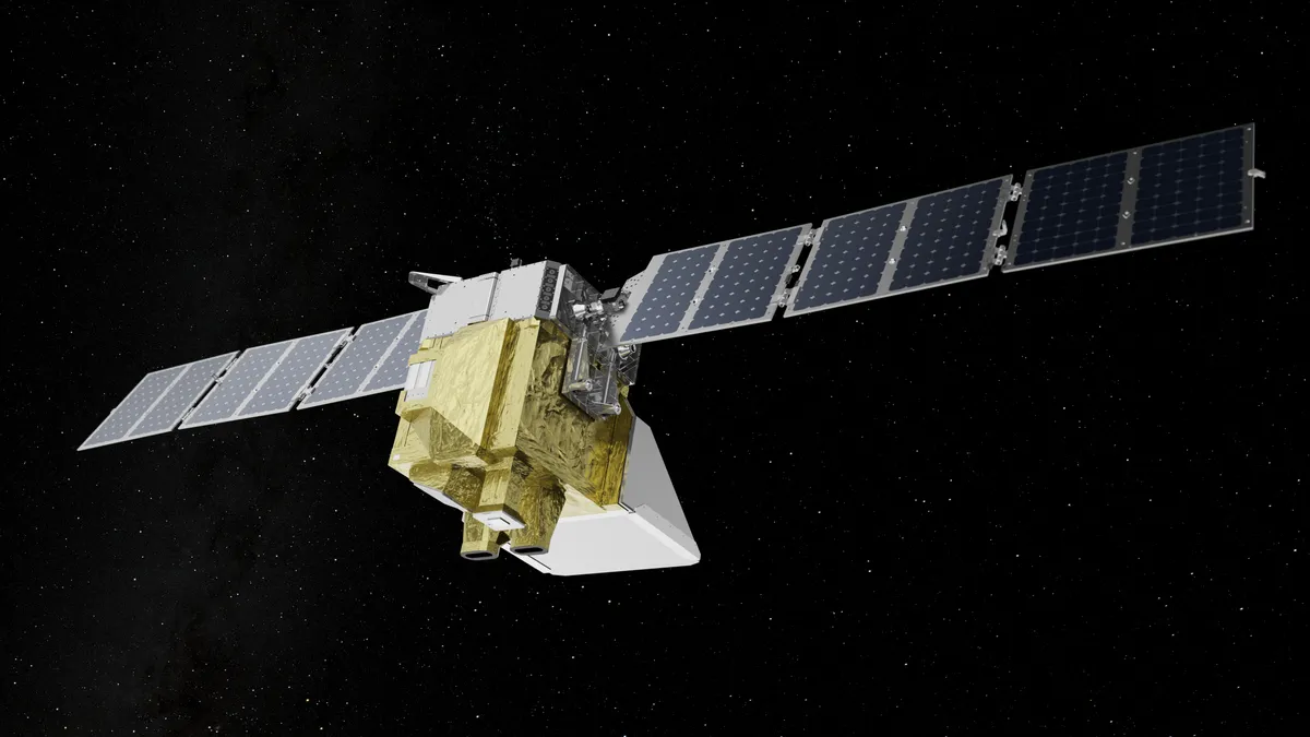
Launched in March, MethaneSAT is the first emissions detection device sent into orbit by an eight-party partnership including the Environmental Defense Fund, Google and Harvard University.
What looks like a gold box with solar panel wings will scan the Earth in 200 kilometer-wide swathes, creating images with a higher resolution than other devices of its kind that are already circling the globe and detecting methane. The satellite will also pick up on point sources releasing over 500 kilograms of methane per hour. A publicly available online portal will host the MethaneSAT data.
While the program is focusing on oil and gas for now, the satellite will eventually record emissions from waste facilities.
Depending on when MethaneSAT starts its waste operations, Carbon Mapper might have its satellite watching landfills first. This year, the first satellite Carbon Mapper is launching as part of a broader coalition, named Tanager-1, will go into orbit looking at a range of major methane sources — from oil and gas to landfills to wastewater treatment plants.
The nonprofit, which blends university and philanthropic backing, has conducted all of its landfill methane sensing so far with EMIT aboard the International Space Station, AVIRIS-NG and the Global Airborne Observatory. The latter two use methane detection systems aboard airplanes and were part of a recent study from Carbon Mapper, published in Science, showing that just over half of all open U.S. landfills the team surveyed were significant sources of methane emissions.
Measurements done via satellite are more cost-effective than when done by the plane-mounted technology, said Dan Cusworth, director of science at Carbon Mapper. How frequently the satellite will return to each of its targets has yet to be determined. Tanager will view swathes of 18-22 km at a time, so just because it cruises past a location doesn’t mean it can pick up all essential methane sources in the area. Carbon Mapper plans to launch at least one more future Tanager, with the goal of keeping a more regular schedule as more devices are in orbit.
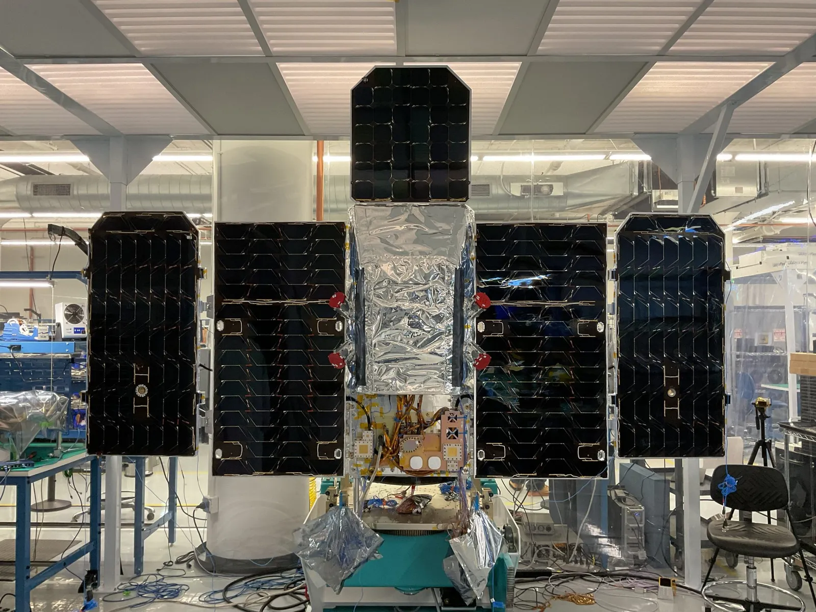
As Carbon Mapper generates more data, the Waste Methane Assessment Platform can add it to its database.
Launched in December 2023, WasteMAP compiles landfill methane measurements and estimates into a single global map. Users can zoom in to specific landfills and see how many tons of methane each facility is estimated to release annually. This data, hosted by RMI, draws on direct readings like those from Carbon Mapper, as well as reported emissions from programs like the European Union’s Emissions Database for Global Atmospheric Research and results based on a modified version of the EPA’s Solid Waste Emissions Estimation Tool.
Right now, each data source operates as an independent layer — no site-level emissions estimates are a blend of remote detection values and calculated emissions. Eventually, RMI would like to change that, but for the next few years, the priority will be adding more direct measurement data, said Ellie Garland, a senior associate with the organization focusing on industry methane emission reduction. For all the growth happening in remote methane detection, only a small fraction of facilities in the world have had their emissions assessed this way.
“The reason why we have this pretty complex architecture in place for WasteMAP is that as we start getting more data, we can start stitching it together,” said Tom Frankiewicz, who leads RMI’s efforts to mitigate emissions in waste management.
RMI is also talking to a range of other organizations to see if they’d like to contribute their information to WasteMAP. WM and the Environmental Research & Education Foundation recently worked with RMI on a playbook describing the role that detection technology could have for landfills. Frankiewicz said other waste companies and municipalities have reached out about using or adding to the tool, too.
In a written statement, WM said it deploys satellite, aerial and ground-based technologies and compares the collected datasets to get a sense of accuracy. WM also works with other organizations to evaluate the equipment.
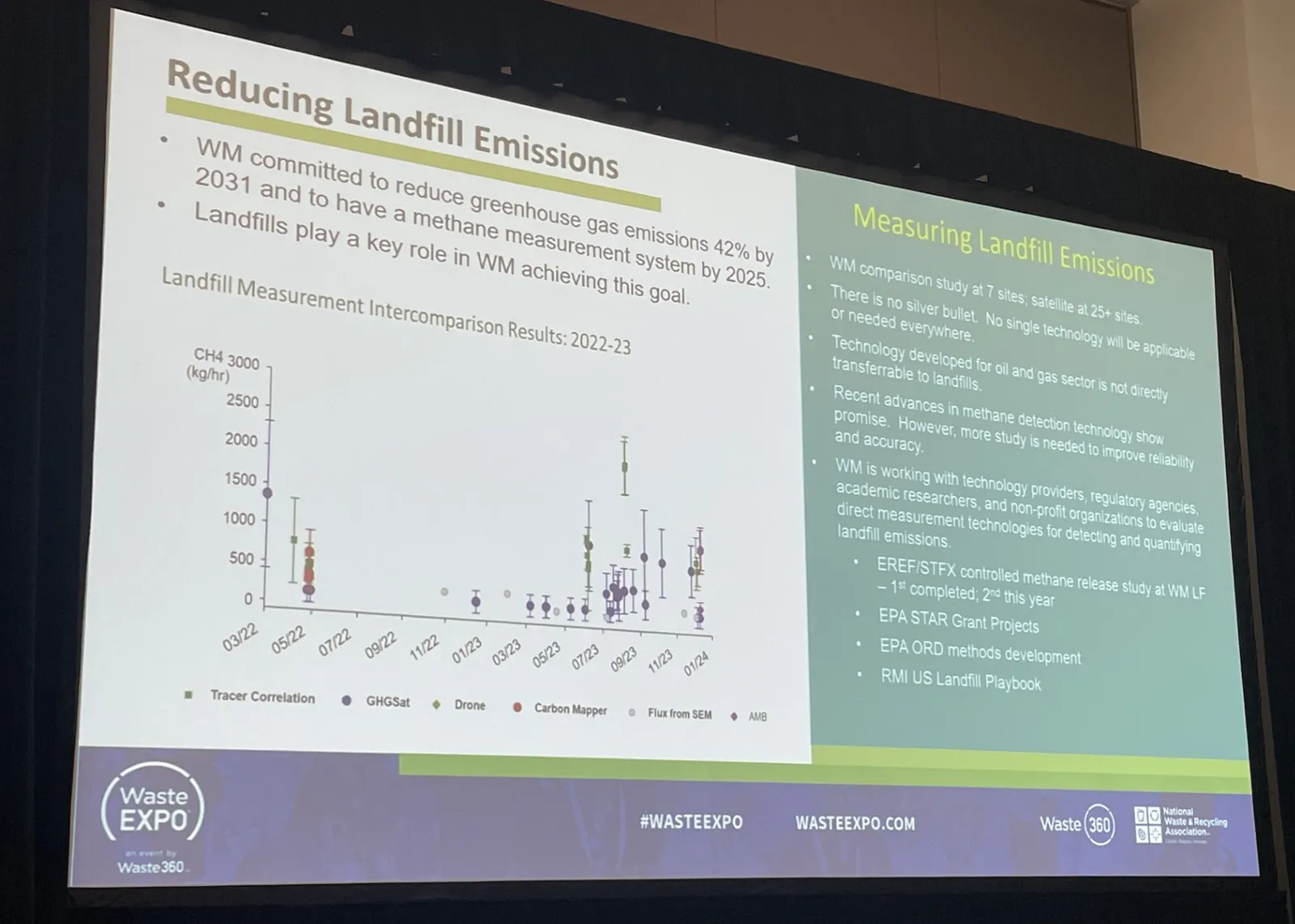
Amy Banister, senior director of air programs at WM, elaborated further during a presentation at WasteExpo in May. In early 2024, WM selected seven sites to receive quarterly barrages of emission measurements from satellite, flyover and land-based detection gear.
“One of the challenges is trying to get all this technology to line up on the same day. It just doesn't happen,” Banister said. Though the ideal comparison approach would have all the technology operating together, weather and other conditions can mean that fitting all the measurements into a single week is a success.
The company is also linked to three of the five projects that received Science to Achieve Results grant funding from the EPA in 2023 to study monitoring and modeling landfill emissions. With another program running test methane releases for monitoring at one landfill site, “we're really trying to hone in on the accuracy and reliability of these technologies before we pick our ponies,” Banister said.
Integrating feedback from a wide range of satellite, airplane and drone programs could be easier if a federal standard set protocols. Without guidance on how to deploy the different options and how resulting data is reported — and without incentives for remote detection in the first place — tying together inputs gets challenging, said Frankiewicz.
What’s next
While private initiatives are trying new technologies and figuring out how to integrate various readings, government initiatives to implement the same gear over landfills are farther behind.
Washington state, for example, announced updated landfill emission regulations this past May. The policy — which affects about two dozen sites — requires gas collection and control equipment and quarterly emissions testing, but the latter will be done by “instantaneous surface monitoring procedures.” According to an Industrious Labs report, the drafted rules “[fail] to provide for monitoring using improved technology.”
The same day that Washington state announced its new monitoring program, nine U.S. senators requested that the 2025 Interior and Environment Appropriations bill give the EPA funding to help states put satellite or flyover-based sensors into action over landfills.
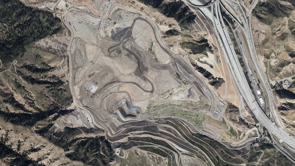
Some industry practitioners, such as environmental engineer Eugene Tseng, would like to see the array of detection technologies get even wider. Tseng, who is also an attorney, is currently working as an independent advisor with the Sunshine Canyon Landfill Local Enforcement Agency in California. He has also worked with Carbon Mapper, the NASA Jet Propulsion Laboratory and other researchers on satellite-based and plane-based methane detection.
He said that the closer to real-time the aerial methane measurement is conveyed, the easier it is for his team to learn what’s causing any detectable leak — whether it is a crack in the cover or a new animal den. Delays from when flyover technology takes photos to when the calculated methane hotspot data is publicly available can sometimes be a month long. Making best use of the feedback requires matching the information with that day’s weather, barometric pressure, where material was tipped, waste types and more.
“I maybe spend about 1% of my time looking at the aerial imaging, but all the other stuff is looking at the actual operational data from all the different agencies and trying to make sense of that,” Tseng said.
Ideally, Tseng said methane-detection rovers would scramble over landfills and provide instant feedback from mere inches above the surface — pinpointing the exact locations and conditions generating the emissions.
WM’s Banister said the constant flux of operations at a landfill make it challenging to build single-site measurements into a broader assessment of long-term emissions. WM wants a greenhouse gas measurement system running by 2025 to help evaluate how well it’s approaching the goal of a 42% reduction in scope 1 and 2 emissions by 2031, and is keeping its options open.
”We're realizing that there is no one technology to rule them all,” Banister said. “It's going to take a suite of technologies.”
Even if follow-up work is needed after a remote methane measurement to figure out the underlying causes, the eye-in-the-sky approach can at least identify priority areas, like leaks or super-emitters, more quickly.
Blauvelt said a 2019 study published in Nature indicating that 10% of point sources identified in California accounted for 60% of all point source emissions supports this idea. The research team behind the paper relied on airborne methane imaging. Not applying a similar approach nationwide has consequences, she said.
“It's leaving just a ton of methane emissions on the table that could be better mitigated.”
Cole Rosengren contributed reporting to this story.
Disclosure: WasteExpo is run by Informa, the owner of Waste Dive’s publisher, Industry Dive. Informa has no influence over Waste Dive’s coverage.


